Communities Within Kittitas County
Kittitas County is full of contrasted landscapes that serve as backdrops to play and learn, Central Washington is a premier destination for year-round outdoor recreation, education and growing businesses. Along the I-90 transcontinental interstate, Kittitas County covers over 2,300 sq. miles of land with enriched agriculture, historical architecture and and economic development. Choosing Kittitas County as your home is something you will won't regret.
There are 45,225 Citizens in Kittitas County!
Our Neighbors
The community of Snoqualmie Pass traces its history back to the history of the Chicago, Milwaukee, St. Paul and Pacific Railway as it developed the main line construction from Seattle to Chicago beginning in 1906.
A community called Laconia was developed to house the mountain helper engines, which assisted trains across the pass. The railroad had a turntable, engine house, depot, water tank, passing tracks, while the community had a hotel, bunkhouse, and houses for those living there. Freight and passenger service began in June 1909, and additional services were added in May 1911.
The historic Indigenous trail turned wagon road was designated a state road in 1905 and improved upon, becoming the Sunset Highway in 1913. It was upgraded and dedicated in July 1915 and became part of the Yellowstone Trail Road. In 1928, the highway was shifted slightly from running through downtown Snoqualmie Pass to the existing route of Interstate 90.
Easton was platted by brothers Albert O. Johnson and William W. Johnson on June 24, 1902, and was known for many years as a sawmill point. It was named Easton as the last station of the Northern Pacific Railroad on the east side of the Cascade Mountains before it crossed through Stampede Pass. It also offered a stop for the Chicago, Milwaukee, and St. Paul Railroad before it crossed Snoqualmie Pass to Puget Sound. Early residents of the community were engaged in the lumbering, railroad, or similar businesses. Easton is primarily known for its scenic and recreational opportunities today.
The City of Roslyn was named by Logan M. Bullitt for his hometown in August 1886. Bullitt platted the community in September 1886 on behalf of the Northern Pacific Railway, after the coal fields were discovered earlier that year and opened for commercial operation through the Northern Pacific Coal Company. Immigrants were those who first came to work in the mines, mostly being of Slavic, Italian, and English descendent; but as workers started to strike to improve the working conditions and wages, black workers were brought in from the Eastern and Southern United States to serve as strikebreakers.
When the coal industry ended in the region in 1963, more than 50 million tons of coal had been shipped. In 1975, William Craven was selected to fill the vacant mayoral slot in Roslyn and became the first Black mayor in Washington State history. Roslyn has also been known for the being the setting of the TV show, Northern Exposure, which was filmed from 1990 to 1995. The Roslyn Cemetery was established as 25 separate ethnic or fraternal lodge affiliated cemeteries.
The community of Ronald was established around 1888 as a smaller coal mining town northwest of Roslyn, as it also was at the mouth of Mine No. 3, Roslyn Coal District. It was named in honor of Alexander Ronald, one of the early superintendents of the Roslyn mines. The town had a series of businesses throughout it, but it became most remembered for Falcon Pool and Dance Hall, which was owned and operated by Bert Pellegrini in 1928.
On August 18, 1928, the 250-gallon moonshine still that was located in a hidden room below the Falcon Pool and Dance Hall exploded, spewing burning alcohol across several building and the town itself was in flames within minutes. The fire gutted the business district, with the exception of Modern Bakery, and destroyed 32 homes. The only person to die during the fire was Pellegrini. The town itself was also impacted with the closure of the nearby mines, which removed the town’s support.
When the Chicago, Milwaukee, St. Paul & Pacific Railway was preparing the rail line, it established the area of Cle Elum as the division point between the Coast and Columbia divisions. South Cle Elum was identified as a community site when it was determined that the rail line would end up running one mile south of Cle Elum.
The Milwaukee Land Company platted the first plat, and offered the community land for sale in November 1908 as the last division town. A post office was opened in July 1910, and other businesses were identified as opening in that time period as well, such as a branch of the Johnson Brothers store from Easton.
The town was officially incorporated on August 28, 1911.
The first known land claims for the land presently known as the City of Cle Elum were in 1883, first by Thomas Gamble and later by Walter J. Reed. The community took its name from the K’ti’tas word meaning “swift water,” a reference to the currents of the Cle Elum River.
When the Northern Pacific Railway entered the region in 1886, Cle Elum became important to the railroad not only a depot location but in utilizing the existing logging industry and sawmills, such as those around Lake Keechelus, Lake Kachess, and Lake Cle Elum. Early timber was logged and turned into railroad ties, necessary for expanding the railroad across the Cascade Mountains. Farms were established throughout the region as well.
In both 1891 and 1918, Cle Elum suffered a fire that destroyed the growing community, but the community persevered and rebounded. The City of Cle Elum was officially incorporated in 1902.
The area known as Liberty began in the Swauk Basin. In 1873 the Swauk Mining District was formed after the discovery of gold in Swauk creek. The few miners who began Liberty named their find Discovery Bar. Despite efforts to keep their find secret, the secret was told, and many people came to seek fortunes. The resulting mining camp on the Swauk developed into one of the earliest communities in Kittitas County. It was complete with a post office, school, stage lines, stores and a community center. It was a place that became famous for its Saturday night dances. Unlike the traditional rough bachelors mining camp this community grew into a welcome place for families.
Liberty became known as Liberty in 1892 with the establishment of the Post Office, the miners requested Swauk as the name of their Office, but it was too close to existing names. The story goes that the postmaster, “Bull” Nelson (Gustaf Nilson), had invited some of the miners into the new post office and told them “You’re at liberty here boys, so set down, lay down or do as you please.” Later, when the postal inspector asked for a name different from Swauk, “Liberty” was suggested; thus Liberty, became the name of their camp.
A second Mining camp developed in the Swauk Basin, first called Williams Creek Camp, later changed to Meaghersville. By 1895 most of the successful mining had moved to this location, and in 1912, the last of the buildings including the post office were disassembled and taken to Meaghersville. At this time the name of Meaghersville officially changed to Liberty.
The modern Historic Liberty site is actually at the location of the original Meaghersville. The name Liberty remains affixed to both locations often causing confusion.
The community of Thorp was named for Fielden Mortimer Thorp, one of the first permanent settlers of Kittitas Valley. While the community has been known as Oren and Milton over time, records identify that the first plat for Thorp was filed on July 9, 1895 by John M. Newman and his wife Sarah Isabel Newman.
The community has been a small, quiet farming town, serviced by the Northern Pacific Railroad. It also had a small manufacturing center, of which the Thorp Flour Mill was established in 1883 and continued operation until 1946. The Northern Pacific Railroad depot closed in the 1950s, and a series of fires affected the industrial areas, causing a decline of the small community.
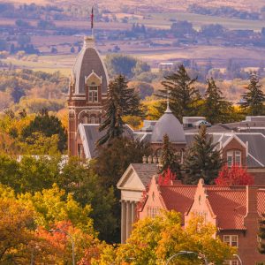
At the heart of Kittitas Valley and located on the historic homelands of the K’ti’tas and Pshwánapam bands of Indigenous people still steward the lands presently and share the stories of their ancestors, the City of Ellensburg was first platted in 1875 by Mary Ellen Stewart Shoudy and her husband John Alden Shoudy.
As the city grew and expanded, it was incorporated in 1882, and on July 4, 1889, suffered a major fire that destroyed 10 downtown blocks and 200 homes. The Washington State Normal School was established in 1891, and today still provides first class educational opportunities as Central Washington University. In 1894, the “h” was removed from the original spelling of Ellensburgh.
Agricultural bounty has always been part of the Kittitas Valley presence, including Ellensburg, with the first major hay exports occurring right after 1900. In 1885, the Kittitas County Fair was established for the community to share the best products grown and made, and in 1923, the Ellensburg Rodeo was established after a long tradition of Sunday rodeos.
The City of Kittitas was platted originally on April 28, 1908 as “Kittitas City” by the Milwaukee Land Company, a division of the Chicago, Milwaukee, St. Paul & Pacific Railroad. It had been named such for the K’ti’tas band of Indigenous peoples who had lived – and continue – to live in the Kittitas Valley, stewarding the land and sharing the histories passed down from their ancestors. The first businesses established were agriculture warehouses along with a post office, general store, and church around the small depot, which put Kittitas on the map.
Kittitas was officially incorporated as a city in 1931. In June 1932, Kittitas suffered a major fire in which many of the businesses along South Main Street were lost, but many later rebuilt. The railroad ended its service in 1977, and the railroad right-of-way in Washington was acquired by the sate and converted into what is known today as the Palouse to Cascades State Park Trail.
In 1910, Willard Van Slyke set forth the design for a community and in 1914, platted an 80-acre in a community for 120 lots, with a 20-acre central easement, on the edge of the Columbia River. He called this community Vantage, which was a play on his last name. Van Slyke operated a car ferry service for those wanting to cross the Columbia River beginning in 1914, and deeded the right-of-way over to Washington State in September 1917.
The state began operating the ferry in October 1917 until it was replaced with a 1,640-foot cantilever bridge on September 8, 1927. The town moved north around the base of the bridge. This bridge was dismantled in 1962, and re assembled at Lyons Ferry crossing on the Snake River, where it is still in use.
In 1933, the town site of vantage with a reduced population of 5 was sold to entrepreneur TJ Stockdale. He first built a Chevron Gas Station, where his wife sold sandwiches to passing travelers. In all, they added a repair garage, Standard Oil Bulk plant, two motels, two cafés, a Richfield Station with a museum and gift shop, a horse ranch, cherry, peach and apricot orchards and alfalfa fields. The population grew to 100.
In 1959 plans moved forward to create the Wanapum dam, the town was forced to move, as the current location would be inundated with the new reservoir. Residents had until 1963 to move to the present location on higher ground. When the dam gates closed, the reservoir filled in 41 hours and the few remnants of the town were lost to the water.
Kittitas County Communities
Kittitas County Major Industries
Higher education and K-12 jobs are important to the local economy. Central Washington University employees over 1,900 faculty and staff, making it the county's biggest employer. State and local government education represented 4,810 jobs in the county in 2016, according to the state's Employment Security Department. That figure includes Central Washington University's student employment.
Central Washington University
Academic Communities:
Ellensburg School District
Kittitas School District
Thorp School District
Damman School District
Cle Elum-Roslyn School District
Easton School District
Central Washington University
Other Schools including: Ellensburg Christian School, Discovery Lab,
Ellensburg Homeschool Co-op and Swiftwater Learning Center
Hay production in Kittitas County is worth more than $50 million annually for growers, with Timothy Hay estimated at $45 million of that in total. In a good crop year, about 90% of the Timothy Hay crop is exposed overseas to Japan, South Korea, United Arab Emirates, Vietnam and other Pacific Rim counties. Several Ellensburg-area commercial hay companies buy hay in agreements with overseas customers, and local firms process the hay, transport it through ports in Seattle and Tacoma. Valley growers also produce orchard grass, alfalfa, Sudan grass, sweet corn and potatoes.
The beef industry in Washington contributes significantly to the state's economy and was ranked the fourth largest agriculture commodity in the state in 2016. Cattle ranches in Kittitas County are still operated today by second, third, and even fourth-generation ranchers.
Fruit orchards are another healthy cash crop in Kittitas County. As technology continues to produce new varieties of apples and pears, demand for these crops continues to grow. Orchards are primarily located on the southern rim of the valley.
Kittitas County has seen more construction jobs in recent years with residential construction, large building projects at Central Washington University and road projects. Manufacturing firms include Shoemaker Manufacturing and Zacklift International in Cle Elum, along with a number of agricultural-based businesses.
Total visitor spending was estimated at $177 million in 2015. The Suncadia Resort in Upper Kittitas County is a major contributor to the economy through its amenities for visitors and residential properties.
The Kittitas County Chamber of Commerce is involved by sponsoring a series of events and running tourism programs for the county including cities such as Kittitas, Ellensburg, Cle Elum and Roslyn. More than 8,500 people stopped at the visitor centers in Ellensburg and Cle Elum in 2017.
Serving as the Destination Marketing Organization, the Kittitas County Chamber of Commerce's Tourism Department works hand in hand with the City of Ellensburg, City of Cle Elum, and the county to promote Kittitas County as a premier tourist destination, and helps provide a seamless experience for travelers when they visit. With partners in lodging, niche tourism, recreation and events, the Tourism sector produces award-winning multi-channel strategies and infrastructure plans. This work showcases our destinations tourism drivers supports our local economy by providing thousands of jobs, and increases tourist spending for the county's largest industry.
The Kittitas Valley is home to three major wind projects as well as several solar arrays, making it one of the Northwest's leaders in clean energy. Puget Sound Energy's Wild horse Wind and Solar Facility, 16.5 miles east of Ellensburg, has a popular visitor facility with 360-degree view of the Kittitas Valley, Mount Rainer and the great Columbia Basin to the east. Other wind projects include the Vantage Wind Power Project and the Kittitas Valley Wind Power Project.
Municipalities
Schools
City of South Cle Elum
Snoqualmie Pass Community Association
Employment
1,316 Small Businesses
21,830 Employees
6.8% Unemployed
Education
24.9% High School Graduates
34.2% Some College or AA Degrees
32.3% Bachelor's Degree or Above
Kittitas County Arts and Culture
Sources: awbinstitute.org, census.gov, walkscore.com, weatherspark.com, bvestplaces.net, end.wa.gov
*Data as of June 2022